|
|||
|
|||
|
|||
|
|||
 Home > LAW BOOKS > General Interest > Reference > General Books > 2012 Home > LAW BOOKS > General Interest > Reference > General Books > 2012 |


 5
5
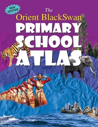
This completely updated edition of The Orient BlackSwan Primary School Atlas is friendly and specially enriching for the young learner. It has a variety of maps, photographs, illustrations and statistics presented in an attractive, informative and child-friendly way. Some of the special features are: a satellite map of India as seen from space maps of Indian states and union territories thematic maps, showing Indias climate, national heritage, festivals, transport, tourist places, vegetation, soils, minerals, industries and natural hazards historical maps, showing how India has changed over the ages continental maps of the different continents world maps with important features of the world all 196 flags of the world, including flags of newly-formed nations an easy to use index of place names and much, much more.The Orient BlackSwan Primary School Atlas ...brings the world to your child

|

Click on TITLE to choose available options.
|

|
Click on TITLE to choose available options.
|
![The Practical Lawyer - PLW [Annual Subscription]](https://s3.amazonaws.com/ebcwebstore/images/the-practical-lawyer-magazine-annual-subscription.png)
|
Click on TITLE to choose available options.
|

|

Click on TITLE to choose available options.
|

|
Click on TITLE to choose available options.
|

|
Click on TITLE to choose available options.
|

|
|

|
Click on TITLE to choose available options.
|

|
Click on TITLE to choose available options.
|

|
|
|
||
|
||
|